


Everyone has a plan to “Get Out of Dodge” in an emergency. As I teach my self defense and firearms classes, I ask people and they all say, “I’d head up to my cabin” or “I’ll head out west”. The problem is, have you actually considered how you will leave the immediate area of your home or work? Most of the people I hear begin their plan ambiguously. They say, just simply, “I’d leave town”, but they have never done any reconnaissance or real-life consideration of their route.
As humans, we are creatures of habit. If I want to leave my house in Metro Detroit and head to my cabin, I just jump on the freeway two blocks from home and take it most of the way, right? Well, on a normal weekend, without any unrest or an emergency, that’s very simple.
These basic plans fall apart once we consider the effects of a large civil disturbance, a disaster, or simply a large-scale long-term blackout. With the increasing trend of protesters blocking the freeways and major streets, these issues must be taken into consideration.
As the crisis unfolds, people will take to the streets in many ways. Protesters who may be out, people seeking to re-unite with family members, looters, people seeking supplies, and people trying to leave the area will all clog the roads. Authorities will attempt to retain control by establishing traffic control points and roadblocks. Roads and highways may also have been damaged.
When planning routes, a simple and thorough process needs to be used. The process begins with locating four different routes to use in the event one is blocked. A map study is a method to predict where issues may arise. You must drive these routes (conduct reconnaissance) to determine where the problems areas are and how to avoid them. Safe havens and supply stops (or absence thereof) must be planned. Final coordination with others at your destination is also needed. We will address these areas in this article.
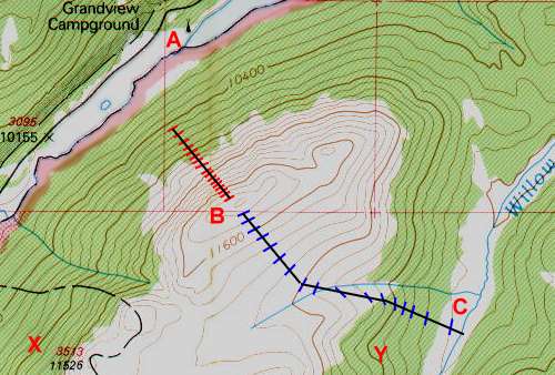
Planning needs to begin with a map study. While GPS technology is convenient and should certainly be planned for, the failure of batteries or other components can happen, so beginning with an old-fashioned map and compass is an important fail-safe. Analyze the map and select routes out of the area that are non-traditional. Sure, the highway is the fastest way out of the area, but the other 400,000 people fleeing the area also know that. I recommend the acronym PACE to remind you to have four routes or plans for everything. Primary, Alternate, Contingent, and Emergency.
As you are studying the map, think from the perspective of the local law enforcement agency trying to maintain order. Decide where Traffic Control Points (TCP) would be placed to best control traffic. Decide what government buildings will either be heavily protected or draw protesters/refugees. Make your routes to avoid these areas. Mark grocery stores and gas stations on the map, and avoid these areas. They will be magnets for looters or just desperate people. Mark and avoid all hospitals, again, during a crisis; these will be busy areas and present a risk.
I have designed my routes to use only secondary roads. While larger traffic arteries move faster under ideal circumstances, they will be at a standstill and will attract the most law enforcement, protest, and refugee attention as well. Ensure that the secondary roads you use don’t traverse high-crime areas.
After selecting at least three routes using only secondary roads, select as your Emergency route something completely out of the box. As an example, I live two blocks from the start of a walking trail that leads all the way through the south side of my city and avoids all major intersections. The trail is wide enough for a vehicle and the reconnaissance showed it’s usable with special equipment (bolt cutters). It also connects with a private dirt road along the power lines that are used to check the transmission lines. This gives me yet another route option in a different direction that also avoids major intersections.
Once you have selected the routes, drive them to validate the selections. Watch for bridges that can easily be blocked, high-crime neighborhoods, grocery stores and gas stations to be avoided, as well as police and fire stations to be avoided. Ensure that the route doesn’t have special hazards that aren’t visible on the map, like narrow streets easily blocked with on-street parking and one-way areas. Avoid routes that lead through subdivisions with a lot of cul-de-sacs. Make sure there is always a way out of any congested area along these routes. Drive them both in daylight and darkness. My personal plan involves leaving between 3 and 4 AM (slowest human reaction times), and so I have done recon on my routes during that time frame. The reason is that if you drive through a neighborhood during daytime, you won’t have a feel for how many cars are parked on the street at night. A lot of on-street parking at night creates a zone where attackers can ambush you (using the vehicles for cover) and can make it very easy to box you in by having a vehicle come at you while a second ones pulls up behind you. With cars on both sides, this is a no-win scenario. Continue to drive the routes on a regular basis to ensure that you are aware of any new issues, like construction, changes in traffic flow, and any new businesses that need to be avoided.
After selecting the routes from your home out of the immediate area, next select routes from workplace. However, your work is now double because you will need to select routes from work to home, as well as routes from work directly out of the immediate area. Yes, it’s a lot of work, but prior planning makes emergency response that much easier. Use the same process of map study and recon to select the routes. It will make you more secure as well, because taking multiple routes to and from work keeps you safe anyway. The reason for having both destinations is that the level of emergency may dictate an immediate departure from the area without a stop at home. Also, the location of the situation may be between your workplace and home.
Once we have our routes out of the immediate area planned and vetted, it’s time to analyze routes from the area to your “Get Out Of Dodge” location. Again, start with the map and select four routes. When picking out a map, purchase a state Atlas/Gazetteer type, rather than a DOT fold-out map. The reason is that the average citizen is going to use routes on a fold-out map, and the Atlas type shows many good roads that aren’t listed on the state highway map. I chose routes that avoid any city and looked for farmland or very small villages. These small towns will likely have a locally-owned and operated gas station or store that may remain open for emergency supplies, but I wouldn’t count on it. If you must cross interstates, look for crossings under them away from interchanges. Traffic control points are likely to be up at on and off ramps and traffic may be forced off right into your path.
It’s very tempting, once you are away from an urban area, to try and transition to an interstate or other freeway. Don’t fall into this trap. These highways are designated as “limited-access” and their actual purpose is to facilitate the movement of government vehicles in an emergency. They have on and off ramps not for travel convenience but for the ability to “seal off” all non-essential traffic. As they are fenced on both sides usually with a ditch on both sides before the fences, there are very easy to block, trapping you.
Once the routes from your original location to your hide-away have been selected and recon done, it’s time to turn your attention to final coordination with others at your hide-away or “Get Out Of Dodge” location. Even if it’s only you there, there are some steps that will need to be taken for safety. Once you get close to the location, don’t plan to drive straight in, even if it’s just you and your family. Plan and select a hidden location near your final destination where you can stop your vehicle and conceal it briefly and walk in on foot. It would do you no good to have made a great escape plan, executed it flawlessly, then blunder into your hide-away to find it already seized by others who may be unfriendly.
If it’s a single-family property, set up tell-tales to determine if anyone has been on the access road or driveway. These can be as simple as a string or branch left across the road. Walk in, using a covered and concealed route and observe to ensure that no one has taken over your hide-away. Once you have determined that it’s secure, bring in your vehicle and execute your security plans.
If it’s a multi-family situation (like mine), have a plan agreed upon by all and allow no deviation. Our plan consists of stopping the vehicle short of the location and making radio (don’t rely on cell phones). Once radio contact is established, an all-clear pass phrase is given. Even though the pass phrase is given, a radio stays with the vehicle and another radio-equipped person walks in on foot to visually verify the situation. Only after all steps are verified is the vehicle then called in.
Once all the routes have been planned and verified, continue to review and update your plan regularly. Once a month is a good idea, but once a quarter is a minimum. I live in an area with serious seasonal changes, so updates will be needed in the event of winter snow, spring floods, et cetera.
The final step is the development of a “travel security SOP”. By this I mean a set of procedures to ensure your safety and security while on the move. First, as harsh as it sounds, consider that you will not stop to render aid to others. This is a personal choice, but many ambush scenarios begin with staging someone needing assistance or the person who truly needs help may have just been ambushed by others. Try to send help using a radio or other communications, but stopping should not be part of the plan. Understand that whatever disputes or conflicts you encounter, they are not your fight and you will either continue straight through or avoid them. Another consideration is security at relief breaks. A trip that may have taken three hours on a normal weekend may take 10-12 hours or even longer. One person should always be posted as security with the vehicle, and no one should go out of the other’s sight. If you are traveling alone, decide upon safe locations and procedure ahead of time (like driving off the main route and out of sight first).
Keep the vehicle fueled and have snacks stocked in it at all times, along with plenty of water to eliminate the need for stops.
Also, ensure that you bring along maps and a compass, just in case you need to change the plan on the fly, based upon the conditions you encounter. If a road is blocked or impassable, having a paper map to quickly make changes is vital. The navigator (person designated ahead of time) should follow your progress on the map diligently, so that if an emergency change must be made, valuable minutes won’t be wasted trying to figure out where you are on the map.
Most plans involve leaving the immediate area, but don’t consider planning how that will be done. Following the steps in this article will help you establish a secure plan that has options in the event of an emergency. The more plans you have ahead of time, the less stress you will encounter when it’s time to get out of dodge. In an emergency, it’s time to move, not time to plan. Movement is life.