


(Continued from Part 2.)
The Weather
The next thing I look at when starting a trip plan is what the weather will be like at my destination as well as locations between my destination and home. For a shorter get-home journey these may be pretty much the same, but depending on distance, terrain and weather patterns you might experience very different weather in locations even 10 miles apart. For route plans that I use on a regular basis I’ll usually include monthly averages chart and just check the 10-day forecast shortly before I pack. Here’s a screen clip of the monthly average chart for Elk River, Idaho from U.S. Climate Data:

I paste this screen clip for the destination, my home location and for intermediate locations (for longer trips) into the Joplin route plan for destinations I visit on a regular basis. For one-off trips and the day before any trip I also visit Wunderground and look at the 10-day forecast. Here’s an example for Tacoma, WA:

Note that I’ve customized the Wunderground display to eliminate some non-critical information and reduce clutter. I paste the screen clip into the Joplin trip plan and synchronize my mobile device, and print off a separate hardcopy of just the forecast so I don’t have to re-print the entire route plan.
Another useful set of data that can impact your route planning is information on hurricanes and cyclones. Wunderground provides a list of all known Atlantic and Pacific storms, along with their projected tracks and strength. You can access this under ‘Severe Weather’ on the top of the page.
I use the weather data to adjust my planned pace and the kit I need to bring – for example, if there’s going to be a major snow storm 5 days out and I end up having to walk home, I’ll add additional time for the trip and focus more on identifying possible shelter along my planned route. The same applies to extreme hot or cold temperatures, heavy rain, etc. Heavy rain can also cause flooding, so I take a close look at low-lying areas along my route that I may need to avoid. In the US, FEMA provides a decent map that shows potential flood areas; you’ll need to zoom in pretty close to get a usable level of detailed information, and the web site is usually pretty slow, so be patient. During some types of disasters like an attack against the power grid, flood-control systems such as dams, spillways, flood gates, etc. may not be operational, so the chance of flooding may increase.
The forecasted weather will also drive the weather-appropriate kit that you’ll need to bring. I look at the lowest and highest forecasted temperatures and use those values for planning my clothing, shelter and sleep system.
Danger Will Robinson!
Weather is only one factor you need to consider when planning a get home route. There are lot of other potential obstacles and hazards that can impact your route and travel times that should be considered in your route planning.
Accidents at nuclear reactors near your planned route are one potential hazard that you should consider. At the time of this writing there are 92 power-producing nuclear reactors in operation in the US, and the Nuclear Regulatory Commission defines a 20-mile ‘Emergency Planning Zone (EPZ)’ around each of them, although the actual impact area will depend a lot on geographical features and weather (winds). There’s also an international version of the map available that shows the locations of reactors around the world. The Windfinder web site is a great resource for finding the projected wind speeds and directions for up to the next eight days, so you can combine that with the location(s) of any nuclear reactors within 20 or so miles of your route to get an understanding of areas where the winds might blow any fallout from a reactor accident. Modern nuclear reactors are incredibly safe, but events such as earthquakes, EMP, terrorist attacks, tsunamis, etc. can still overcome the built-in safety features and result in the release of radiation (just ask the folks in Fukushima Japan).
![]()
I’m not going to talk too much about GHB kit in this article, but one item that I highly recommend always carrying when you’re any significant distance from home is a NukAlert radiation monitor. It’s an extremely small and lightweight (.9oz) device that you can clip onto your belt, backpack, etc. and it chirps when it detects increasing amounts of ionizing radiation (the kind that can give you cancer or kill you) – the greater the number of chirps the more radiation it’s detecting. It’s always on and the battery can last up to 10 years, so you don’t have to fumble with taking out a handheld Geiger counter, turning it on and scanning for radiation, assuming you even suspected radiation was present to begin with.
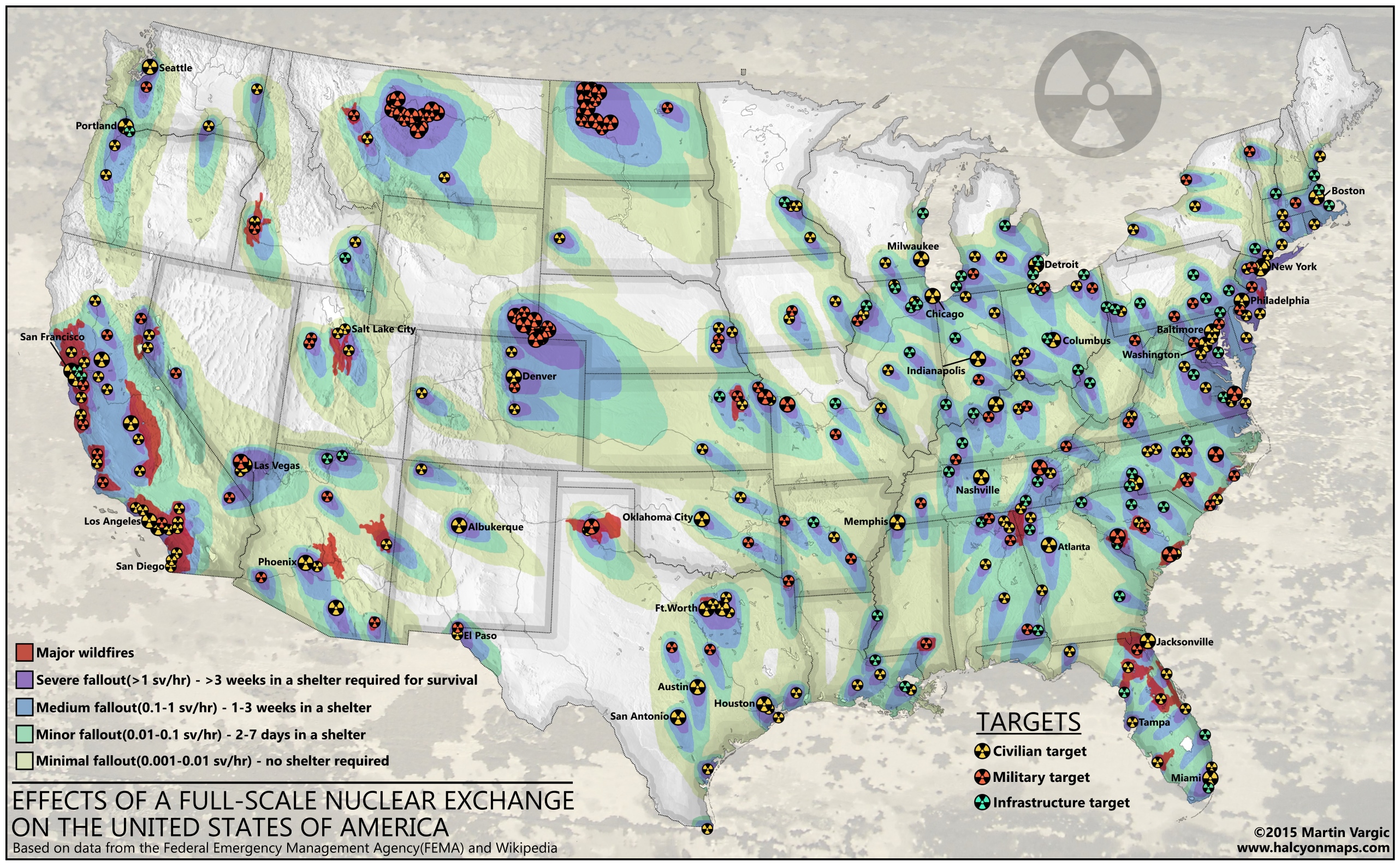
Somewhat related to nuclear reactors is the specter of a nuclear weapon being detonated. This could be a dirty bomb set off by a terrorist, a rogue nation-state detonating a single weapon on a ship or airplane, or all-out nuclear war between nations. Halcyon Maps has an interesting map that shows projected fallout from expected nuclear targets in the US, and the NukeMap web site allows you to designate your own target, type of weapon and type of detonation (air or ground) and see what the resulting destruction zone and fallout effects would be. Here’s an example of a map showing the effects of a 3.3 megaton Chinese weapon with a ground detonation at Wichita, Kansas:
![]()
KI4U has detailed maps of possible nuclear attack targets in the US by state that you can use if you’re worried about a nuclear attack and want to take potential fallout into consideration as part of your route planning.
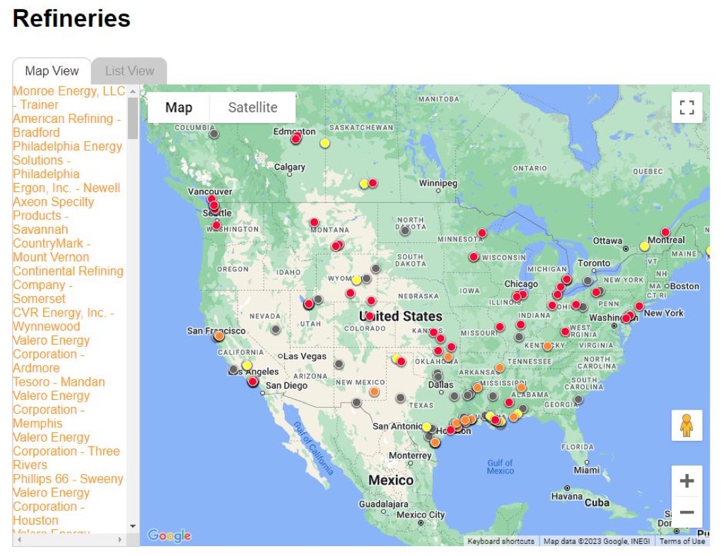
Nuclear radiation isn’t the only potential airborne hazard along your route – chemical plant explosions and other accidents can release clouds of hazardous chemicals into the air, threatening your health and even your life. There are systems in place to alert the public in the event of a chemical plant disaster, but if a large-scale major disaster has occurred those systems may not be operational. In the US the EPA used to publish a detailed listing of locations where dangerous chemicals are processed or stored in significant quantities, but they took those down and deleted all references to them post-9/11 as a potential security risk. Unfortunately that means it’s extremely difficult for the public to find out if there are major chemical risks in the area. One thing that is available to help you plan is a map of all petroleum refineries in the US and Canada, which are arguably one of the more dangerous types of chemical plants. You can combined that once again with the Windfinder app mentioned earlier to get an idea of where any airborne chemicals released from these plants might go.
Criminal Elements
Crime is another potential hazard that you should plan for, especially if you’ll be moving through or near urban areas. You’ll most likely want to avoid high-crime areas, and the Community Crime Map provides a good overview of the types of crimes that occur in a given area over time. Say for example you’re in downtown Chicago on business and a massive cyberattack takes down the power grid. You need to head west to get home and you want to avoid high-crime areas to minimize risk. Go to the Community Crime Map and zoom in on the Chicago area, then click on ‘Filter’ in the top menu bar. In the pop-up selection window select ‘TIMEFRAME PRESET’ and select ‘1-year’ to give you an idea of long term crime trends, and select all of the types of crimes that you’re concerned about from the checkboxes. When you click on ‘Apply’ you’ll see something like this:
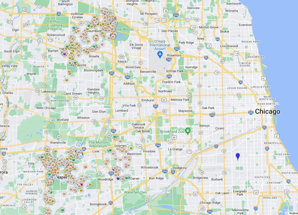
This shows there are large clusters of crime west-northwest and west-southwest of the city, so you should plan your route to head out due west along highways 38 or 64. This doesn’t mean there are no crimes in other areas, just that there are concentrations of them in certain areas.
Closely related to crime are prisons, which is another potential area of concern when planning a get home route. The disaster may render prison containment systems inoperable, prison personnel may decide to leave their posts to head home and protect their families, or the prisoners may riot and escape, although this probably won’t happen for a at least few days after a disaster. The US Federal Bureau of Prisons publishes a map of federal prisons (shown below), but I haven’t been able to locate a single map that shows the locations of all city, county and state jails and prisons. Wikipedia publishes a list of such prisons, and some states publish their own maps, so you’ll have to do a bit of digging to find out if there are prisons along your route you should avoid. My assumption is that after they get out, the majority of prisoners would probably head towards the closest urban area to steal resources and engage in whatever twisted inclinations they may have, so I’d try to steer clear of those corridors later in my route planning, since the prisons should keep the prisoners contained for at least a few days.
Other Hazards
There are a number of other types of potential hazards that may be relevant to your route planning, depending on things like location and time of year. These include:
- Wildfires – If there are active wildfires along or near your planned route you may need to re-route to avoid them. AirNow has a map that shows the location of current wildfires and their associated smoke/particle plumes. Note: Click on the layers button (looks like 3 stacked layers) in the upper right and uncheck the Air Quality boxes to see just wildfires and smoke plumes.
- Volcanoes – The USGS provides a detailed map of all volcanoes in the US and their current status. If your route takes you within 20 miles or so of a volcano with a status of ‘Watch’ you should consider some alternate routes in case it blows while you’re trying to get home.
- Earthquakes – If your route is through an area with a history of major earthquakes you should consider avoiding built-up areas if possible.
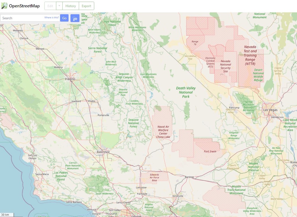
- Military Bases – After a large-scale or widespread disaster the military will most likely be operating at a high state of alert, so avoiding military bases and areas would probably be a good idea. MilitaryBases.com provides a high-level map of all current US military bases, and ORS/OSM show restricted military areas in red. Here’s an example of the bases on the southwest US that you should consider avoiding:
The RSOE-EDIS web site is an additional resource that provides a nice map showing current emergencies and disasters around the world, so it’s not as useful for longer-range planning purposes, but it can provide some useful information if Internet access is still available following a disaster. I have the RSOE-EDIS app installed on my Android phone, configured to only show me alerts for North America, so I could potentially get some useful information that can allow me to refine my route plan before I take off.
(To be concluded tomorrow, in Part 4.)