


This is about our cross-country road trip; not about where we went, what we saw or what we did, but about how we got there and how we found our way back. Why should this journey be of interest to you? Because someday you might have to make a road trip that doesn’t go as planned, or maybe not even planned at all and with little or no technological help. My wife and I are occasional long-distance travelers. The long-distance road trips we have made have been primarily to the same destination for family events via variations of the same routes that ran west to east, which meant we could get there on just one or two interstates or state highways. Otherwise, our typical road travel is recreational in our region on state and county roads with pastures, prairies, cornfields, and forests being the usual scenery. Very rarely does our travel require anything more than a state map and often not even that.
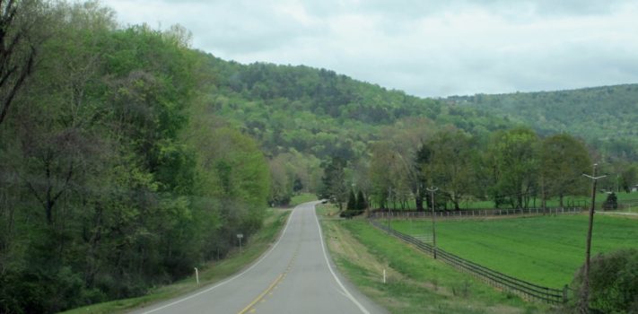
This trip was different for us as it was a route that ran diagonally across the country via several interstates through a number of large metropolises, different climates, weather, cultures, and uncertain economic and political situations. We planned on getting there on the national interstate highway system. After we got there we decided to make the return trip on two-lane state highways. There were the two of us that would be taking turns between driving and navigating.
NAVIGATING
To plan our route before we left I used AAA (American Automobile Association) online trip planning that estimated that it would be a 4,000 mile round trip, taking 3-4 days one way based upon an 8-hour driving day on interstate travel. With the online AAA map I could determine how long we wanted to drive in one day and would place a marker in the general area. With Google Maps, I zoomed in on those waypoints and hunted for fuel, lodging, etc. and printed them out. We got a custom map booklet from AAA, an onboard compass and a Garmin windshield GPS that I could’ve used to upload a route to, but I didn’t take the time to do that. The week before we left we purchased our first smartphone ever, a Tracfone, and a couple weeks before that a Google Chromebook both of which I uploaded Google map directions. The directions sent to the Tracfone worked quite well, but the ones sent to the Chromebook were useless as they were not downloaded and I didn’t realize you needed to do that or be online to access the route I had on Google maps, which we couldn’t do on the road.
Our first day on the road didn’t start or end as planned. We got a late start and drove well beyond our previously planned end-of-day destination. The rest of the trip wasn’t any different in that way so that all the rest stop research I did at home was useless. Instead we relied on the blue signs preceding exits and the GPS location option occasionally for fuel and lodging information. Asking questions at fuel stops and local businesses was very helpful throughout the trip.
On our return trip we used a Rand McNally road atlas, AAA state maps and our windshield GPS. The GPS was used mostly to check speed limits and to set our next destination. The GPS would ask if I wanted to set that as a new destination or as a waypoint. I could’ve set our home as our final destination and then put in waypoints, but I didn’t think I’d ever use that function, so I never learned how.
We learned a few basics about map reading which came down to paying attention to detail. As an example, there was a label on the left side of the road on the map for a campground, so we went there but it wasn’t there. Looking closer at the map there was a faint line pointing to it’s location on the other side of the road. There weren’t always road signs either. We followed a road that we thought was the highway that turned into a dirt road because there was no sign indicating to turn when the highway went that way. And there was more than once when neither the GPS, the maps nor the road signs identified the road by the same name or number. We went down a long rubble pothole road to nowhere when we were supposed to be on a paved road to a campground, drove in a 20-mile circle and got into some hot disputes about where we were and which way we should go. That leads me to the next topic.
COMMUNICATING
Everything we had to navigate this trip was useless whenever the communication between the driver and the navigator wasn’t clear. Often the driver was so aborbed in watching other vehicles, the speedometer once in awhile, and road signs that they couldn’t make out the directions the navigator was giving above the road noise as their directions were spoken to the map in their lap. That was what it was like for me when I was in the driver’s seat. As a result of some of these circumstances we agreed upon a few rules; when the one in the passenger seat isn’t navigating, they need to refrain from making any remarks that would distract the driver or sound like a command. Saying things like “oh look at that big cow” or “look at how long that train is” are examples.
Another thing, only use the word “right” when giving turning directions and never in place of the word “correct”. Otherwise, we would have a conversation like this: driver asks navigator: “turn left here?” navigator: “right”. And so the driver turned right and the navigator hollers “why did you turn right?” Driver: “because you said right”. Navigator: “I said right, turn left here”. Do see the problem? Use the word “correct” to confirm and the word “right” only to indicate direction. We got into some pretty tight spots where the driver had to watch to their left and needed the navigator to keep watch for traffic coming on the right. For those situations the driver asks “Go or No?”. The navigator responds with either “GO” or “NO!”. The navigator had a very demanding task as they have to always be alert when directions were required and they also need to get sleep, provide snacks, water and occasional audio entertainment. Although we had a very superb audio system, we didn’t use it that often. On long straight uneventful drives it was more enjoyable to converse on the scenery, the journey and whatever else came up.
TRAFFIC
Posted speed limits on the interstate, which I described as a road race between traffic jams, were minimum, not maximum limits. We endeavored to neither be the fastest nor the slowest on the interstate, but somewhere a little above the average, which was a higher number than my age. Two lane state highways were different especially when they went through 30 mph speed zones in small towns and cities. Thanks to some local advice, we stuck to those very closely.
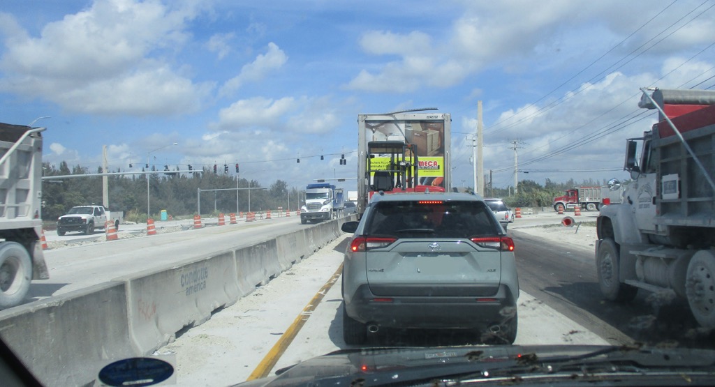 Traffic, more so on the four lane interstate, tends to group into packs with each pack developing its own personality, how close to follow, how fast to go. When I’m in a pack that shares the same speed range and behavior as mine I will tend to conform to that and stay with them, but eventually the pack breaks up. If I get into a pack that is undesirable, I will do what I can, including exiting to get out of it if it is really bad. I dealt with tailgaters at interstate speeds by maintaining our speed with cruise control and let them figure out what to do about getting ahead of us without our help as long as were going with the flow in the lane we were in. Often in the passing lane a vehicle will come up out of nowhere and I couldn’t do anything as the lane next to us was occupied. I just kept moving at my set speed and moved over when possible. When they decided to pass on the right and squeeze in between us and the vehicle ahead, I’d be ready to either slow down rapidly or move onto the shoulder.
I am very cautious when following or passing vehicles towing campers or trailers and large trucks. I make an effort to make life easy for large vehicles and trucks. If I am alongside a truck that is looking like it needs to pass the vehicle ahead of it and my speed is preventing them from passing, I will either slow down to let them go ahead in my lane or most likely speed up and get ahead to let them move over into the passing lane as it can take them quite awhile to complete the pass. I do not want a large truck too close to me ahead, behind or next to me. When I am approaching a long stretch of an incline on a two lane road with two or more trucks in the right hand lane way ahead I stay back as I can expect that one will suddenly pull into the passing lane if the one ahead of them slows down, and I don’t want to be there when that happens.
Incoming traffic is supposed to yield to the traffic, but usually doesn’t and most drivers move over to the outside lane instead of merging. If there is no room to move into the outside lane I have to adjust my speed to the incoming traffic to allow a merge. When I am the incoming traffic, I use the turn signal and either speed up or slow down to merge.
What to do about road construction zones? Many of these have signs warning that it is coming up, that there will be lane changes, and speed limit warnings. At night time when there is no construction taking place, and even when there are workers present, the posted speed isn’t always followed. I stay strictly with the posted speed limit when there are workers present, but on long stretches when none are present I stay with the traffic.
We got stuck on the interstate because of an accident up ahead. We decided to take the exit and followed a road that paralled the interstate until we could get back on after the accident. Like rungs on a ladder we took a road that led back to the interstate miles down the road but when we got within sight of the interstate a train was stalled on the tracks blocking the road. We had to turn back and go on further down in order to eventually get back on the interstate. When we did, some 45 minutes later, we recognized vehicles that had been next to us when we exited that had stayed and waited. I don’t regret our attempt to get around the stalled traffic; I don’t like the idea of being stuck in traffic on an interstate.
I guess the best way to conclude this is to say that we made this round trip without any mechanical problems in a 16 year old vehicle, without any accidents in sometimes extremely hectic traffic and in general were quite impressed with the civility of other drivers. The trip there was fast paced, sometimes 10 hour driving days on the interstate where we saw pretty much nothing but the back end of other vehicles. The trip back on two lane state highways was very long, but very scenic and educational seeing parts of this country we never would see otherwise. Our conclusion is that to make the trip again we would not make an air flight or travel the interstate. We would use a handful of paper maps and take our sweet time on the two lane roads across America. And if you’re wondering how fast I was going back there, I’ve got ¾ of a century on my odometer. Happy trails!