Upon relocation to Texas by truck from the East through the Midwest I realized there will be numerous logistics and potential threats that may come into play during TEOTWAWKI that few might consider beforehand and won’t be able to check on-the-fly without cell service and WiFi. I hope my Midwest and East coast friends can use this information as a tool if they want to make a move West of the Mississippi and appreciate why. As I will show you, there is a huge night and day difference between each side of the Mississippi River. My range of concerns and personal solutions begin with operations security (OPSEC) and traveling risks to end with specific, affordable home defense measures no matter where your eventual destination may be.
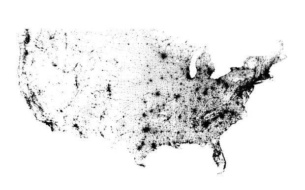
Comparing a U.S. population density map of the 2010 census as one dot per person with a NASA night image map reveals the contrasting networks and densities of our current “techno society”– those in severe anxiety.
 [1]
[1]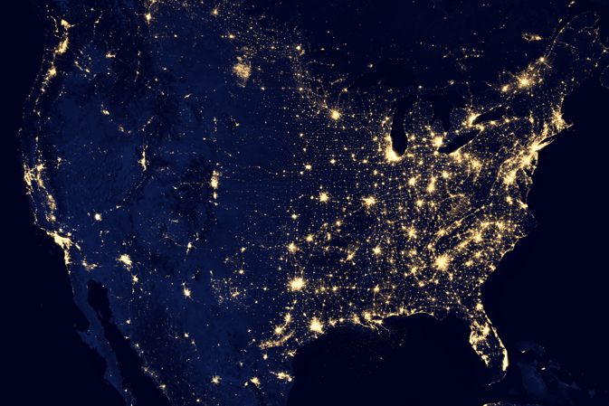 [2]
[2]
If a primary survival strategy is to avoid other humans for the first few months after any potential Black Swan events, then bugging out west beyond the Mississippi river is a viable solution. Potential Black Swan Events prior to TEOTWAWKI may include:
- Financial/Communications/Societal Collapse/Martial Law
- Solar CME (coronal mass ejection)/EMP (electromagnetic pulse)/Martial law
- Geophysical (earthquake, tsunami, super eruption) or Spacephysical Events (asteroid strike, meteor rain, comet cloud)/Martial Law
- CALExit/Aztlan/Martial Law
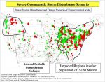
- USA Terrorist attacks/WWIII/Martial Law (Invasion scenarios predict adversaries splitting the country by trying to control the Missisiippi River; I choose to be west of Fig. 3 in that conflict.)
 [3]
[3]

I think you’re getting the bigger picture!
Understanding Our Highway System
Our U.S. Interstate Highway system labels N-S highways with odd numbers, which increase from West to East, and E-W highways with even numbers, which increase from South to North (to avoid confusion with the U.S. Highways, which increase from east to west and north to south), though there are exceptions. The ubiquitous mile markers located one mile apart typically indicate the distance to the next state border or end of road and identifies exits through urban circular loops using clockwise numbers from the south IH intersection. Mile markers on interstate highways can also help you determine which direction you’re going. On most interstates, mile marker numbers begin at the southern state line on north-south routes and increase as you travel north. On east-west routes, the numbers begin on the western state border and increase as you travel east.
Traveling OPSEC
Operational security and situational awareness while traveling is a fluid concern but can be based on scenarios planned ahead and scripted with contingencies for unexpected encounters. A group traveling in separate vehicles should utilize basic two-way radios [4] for communication, always assuming others are listening. Communications using prearranged simple coded messages and keywords protects OPSEC. Never reveal location information; rather, use a scrambled system of reference to mile marker numbers, which to decipher require adding a set quantity (changed each week) and the current days date for the correct number. For example, the transmission refers to MM 68, but you have to add 19 and today’s date to get the correct MM of 96 (further distance than transmitted).
My take on travel OPSEC is focused more toward Risk Analysis with the Impact and Scale vs. Likelihood of a particular event occurring. Using basic traveling knowledge and scripted scenarios helps determine basic alternative routes and responses appropriate to the conditions encountered and maintains the five principals of OPSEC:
Step 1. Track critical information about you, your plans, and resources that could be used by an adversary.
Step 2. Identify who your adversaries might be based on time, location, and circumstances.
Step 3. Determine the various ways your critical information could be compromised, indirectly or overtly.
Step 4. Assess and prioritize the items of information that are the most likely to be used by your adversary and the related countermeasures to use.
Step 5. Apply and integrate your countermeasures and other security for the most vulnerable items, in a priority order.
The military might keep logs for these steps and revisions, but you will make your lists, scripts, maps, et cetera to memorize and then burn them before you leave, since you are protecting your family’s “lives” first. Only keep basic travel document copies available, and the originals safely hidden. Do not keep maps, brochures, or notes of where you are going; just use an available USA atlas for orienteering with non-descript marks as reminders. Consistently tell inquiring minds a destination far beyond and north or south of where you would like to stop, thus explaining the supplies.
Scenario No.1 (Primary)
You and your family are traveling with friends to see relations in another state far away and provide care for a sick relative. Your vehicles are common, basic transportation but with LT-E rated tires, loaded with camping gear to avoid paying for lodging on your limited cash and resources. You carry extra gas to limit your stops and use personal urinals (plastic bottles for men) while traveling. Everyone wears loose fitting,“Good Will” type clothing and old sweaters, jackets, shoes, et cetera without urban tags, graphics, affiliations, or other identifiers; you have a camping upgrade from the “Great Depression” look. Accumulated trash in the car or truck from traveling long distance is apparent, and kids are whining with only comic books to read. Do not wear jewelry, expensive rings, accessories, designer anything, hunting/military/camo gear, or personal electronics you can’t afford in this scenario. OPSEC will require children to be seen but not heard in most scenarios. Remind them of their important contribution to a safe trip, and test them along the way. Read Pslam 8:2, for what it says about “from out of the mouths of babes”.
This scenario is your family training script! Do not attract undue attention, and be sure to look the part you are adopting in every aspect, from clothes to attitude (eyes down respect) and quiet demeanor even when provoked. You don’t behave as a victim but quiet confidence and determination to get where you’re going.
Create similar scenarios from the priority list, and everyone memorize them, including the children when appropriate. Make a verbal travel game out of the exercise for all to share in. Scenarios requiring evasive actions or self defense should be scripted on a need-to-know basis (NSFC– not safe for children). Do not write them down to carry in the car; burn them before leaving. Good OPSEC will include a comprehensive list of things to burn before you leave, because you may not be coming back. Don’t leave anything behind or in the trash that identifies you or your plans. Create a travel cover story for the neighbors just before you leave to explain your recent garage sales, using Craigslist, finding pets new homes, et cetera. Traveling to care for a sick family member can work, if you sell it with conviction and concern. Don’t leave a vacant looking house but ask the neighbors to watch over things and maybe pay them to mow the lawn for a season until you return (sic).
Traveling Risks
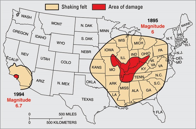
To head West you follow the sun, so why the big whooop? The Mississippi River is a major physical barrier to cross, and floating down it will be treacherous during TEOTWAWKI, particularly where it flows through major urban areas. Dredged to a depth of 9-12 feet by the U.S. Corp of Engineers, the northern stretch above St. Louis varies from 1-2 miles wide to 30 feet (N. Minn.) before floods. When considering potential Geophysical Black Swan events, a repeat of the New Madrid earthquake has to be considered along with its related areas and scope of impacts. The Mississippi bridges are generally oriented W-E, and the New Madrid seismic acceleration will occur in the same general direction. These bridges are not designed to handle large differential horizontal movements and may collapse, or the numerous utilities they carry will snap; both scenarios are dangerous to be around, much less attempting to cross during. The following map shows how the Midwest geology will accentuate and expand these movements as in the 1895 New Madrid, 6.8 quake compared to the areas affected by the 1994 Los Angeles, 6.7 earthquake. The earlier New Madrid earthquakes (four quakes plus after-shocks) from Dec. 16, 1811 to Feb. 7, 1812, registered from 7.5 to 8.0 and created a severe damage zone into southern Iowa and southwest Illinois along the river valley.
 [5]
[5]
If this disaster strikes, crossing the Mississippi will require crossing north of the Ohio river (Cairo, IL.) and probably using an Iowa bridge. Of course, crossing any bridge is subject to political whims, so avoid the big city problems, Interstates, U.S. highways, and railroad bridges. Here is a list of the bridges you might consider:
Iowa Miles north of Ohio River
- Black Hawk Bridge IA 9/WIS 82 Lansing, Iowa (663) 43°21?55?N 91°12?54?W
- Marquette-Joliet Bridge US 18/WIS 60 Prairie du Chien, Wisconsin (634) 43°02?38?N 91°10?33?W
- Eagle Point Bridge (Historical) Former US 61 / US 151 Dubuque, Iowa (583) 42°32?14?N 90°38?34?W
- Dubuque-Wisconsin Bridge US 61 / US 151 Dubuque, Iowa (581) 42°30?56?N 90°38?08?W
- Dubuque Rail Bridge Canadian National Railway, Dubuque, Iowa (580) 42°29?55?N 90°39?01?W
- Julien Dubuque Bridge US 20 Dubuque, Iowa (579) 42°29?30?N 90°39?22?W
- Savanna-Sabula Bridge US 52/IA 64/IL 64 Sabula, Iowa (537) 42°06?16?N 90°09?38?W
- Sabula Rail Bridge Railroad Canadian Pacific, Sabula, Iowa (535) 42°03?51?N 90°09?58?W
- Mark Morris Memorial Bridge IA 136/IL 136 Clinton, IA.. and Fulton, IL. (520) 41°51?53?N 90°10?23?W
- Gateway Bridge (Illinois-Iowa) US 30 Clinton, Iowa and Fulton, Illinois (518) 41°50?16?N 90°11?02?W
- Chicago and Northwestern Railroad Bridge Railroad, Union Pacific Railroad Clinton, Iowa and Fulton, Illinois (518) 41°50?11?N 90°11?05?W
- Fred Schwengel Memorial Bridge I-80 LeClaire, Iowa and Rapids City, Illinois (495) 41°34?49?N 90°21?54?W
- I-74 Bridge I-74 / US 6 Bettendorf, Iowa and Moline, Illinois (485) 41°31?12?N 90°30?48?W
- Government Bridge Automotive and Rail Davenport, Ia. and Rock Island, IL. (483) 41°31?09?N 90°34?01?W
- Rock Island Centennial Bridge US 67 Davenport, Ia. and Rock Island, IL. (482) 41°30?54?N 90°34?54?W
- Crescent Rail Bridge Railroad, BNSF Railway, Davenport, Iowa and Rock Island, Illinois (481) 41°30?42?N 90°35?41?W
- I-280 Bridge I-280 Davenport, Iowa and Rock Island, Illinois (478) 41°28?45?N 90°37?56?W
- Norbert F. Beckey Bridge IA 92/IL 92 Muscatine, Iowa (456) 41°25?21?N 91°02?01?W
- Keithsburg Rail Bridge Railroad (abandoned) Keithsburg, Illinois (428) 41°06?18?N 90°57?10?W
- Great River Bridge US 34 Burlington, Iowa and Gulf Port, Illinois (404) 40°48?43?N 91°05?44?W
- Burlington Rail Bridge BNSF Railway, Burlington, Iowa (403) 40°47?55?N 91°05?31?W
- Fort Madison Toll Bridge IA 2/IL Fort Madison, Iowa (384) 40°37?37?N 91°17?45?W
- Keokuk Rail Bridge Keokuk, Iowa (364) 40°23?28?N 91°22?24?W
- Keokuk-Hamilton Bridge US 136 Keokuk, Iowa (363) 40°23?25?N 91°22?24?W
Missouri
- Quincy Rail Bridge BNSF Railway, Quincy, Illinois (328) 39°56?30?N 91°25?51?W
- Bayview Bridge US 24 Quincy, Illinois (327) 39°56?00?N 91°25?17?W
- Quincy Memorial Bridge US 24 Quincy, Illinois (327) 39°55?53?N 91°25?14?W
- Mark Twain Memorial Bridge I-72 / US 36 Hannibal, Missouri (309) 39°43?13?N 91°21?30?W
- Champ Clark Bridge US 54 Louisiana, Missouri (283) 39°27?24?N 91°02?52?W
- Louisiana Rail Bridge Railroad, Kansas City Southern Railway, Louisiana, Mo. (282) 39°26?43?N 91°02?01?W
- Clark Bridge US 67 Alton, Illinois (202) 38°52?56?N 90°10?44?W
- New Chain of Rocks Bridge I-270 St. Louis, Missouri (190) 38°45?53?N 90°10?25?W
- Chain of Rocks Bridge US 66 Bicycle trail St. Louis, Missouri (190) 38°45?38?N 90°10?35?W
- Merchants Bridge Terminal Railroad Association of St. Louis, MO.Missouri (183) 38°40?29?N 90°11?10?W
- McKinley Bridge Automobile and former Illinois Traction System railway US 66 St. Louis, Missouri (182) 38°39?54?N 90°10?58?W
- Stan Musial Veterans Memorial Bridge I-70 St. Louis, Missouri (181) 38°38?40?N 90°10?42?W
- Martin Luther King Bridge (St. Louis) Route 799 St. Louis, Missouri (180) 38°37?52?N 90°10?46?W
- Eads Bridge Road and Railway, St. Louis, Missouri (180) 38°37?45?N 90°10?47?W
- Poplar Street Bridge I-55 / I-64 / US 40 St. Louis, Missouri (179) 38°37?05?N 90°10?59?W
- MacArthur Bridge (St. Louis) Terminal Railroad Association of St. Louis, MO. (178) 38°36?53?N 90°11?01?W
- Jefferson Barracks Bridge I-255 / US 50 St. Louis County, Missouri (168) 38°29?14?N 90°16?38?W
- Chester Bridge MO 51/Illinois Route 150 Perryville, MO. – Chester, IL. (109) 37°54?11?N 89°50?11?W
- Grand Tower Pipeline Bridge Natural gas Grand Tower, Illinois (80) 37°38?31?N 89°31?03?W
- Bill Emerson Memorial Bridge MO 34/74 Illinois Route 146 Cape Girardeau, Mo. (51) 37°17?43?N 89°30?57?W
- Thebes Bridge Railroad Southern Illinois and Missouri, Thebes, Illinois (43) 37°13?00?N 89°28?01?W
- Cairo I-57 Bridge I-57 Charleston, Missouri-Cairo, Illinois (7) 37°01?23?N 89°12?42?W
- Cairo Mississippi River Bridge US 60 / US 62 Cairo, Illinois (1) 36°58?43?N 89°08?52?W
If that weren’t enough, any large scale Midwest geophysical event may trigger some hidden dangers that span portions of south/central Illinois, southeast/central Iowa, Ohio River valley, and north/northwest Missouri in the form of old and current underground coal (and mineral) mines, many abandoned. Most are shallow mines less than 30-80 feet below the surface and use the “room and pillar” excavation technique where large rooms of coal are removed leaving pillars behind in a grid pattern to support the surface above. These rooms are typically 7’-9’ tall, due to the layered coal seam depths. A major earthquake or aftershock in these areas has the potential to collapse many of these mines, resulting in corresponding sinkholes and surface pits of similar depth.